

Typhoon “ROLLY” (GONI) Severe Weather Update
Severe Weather Bulletin #10
Issued at 08:00 pm, 31 October 2020
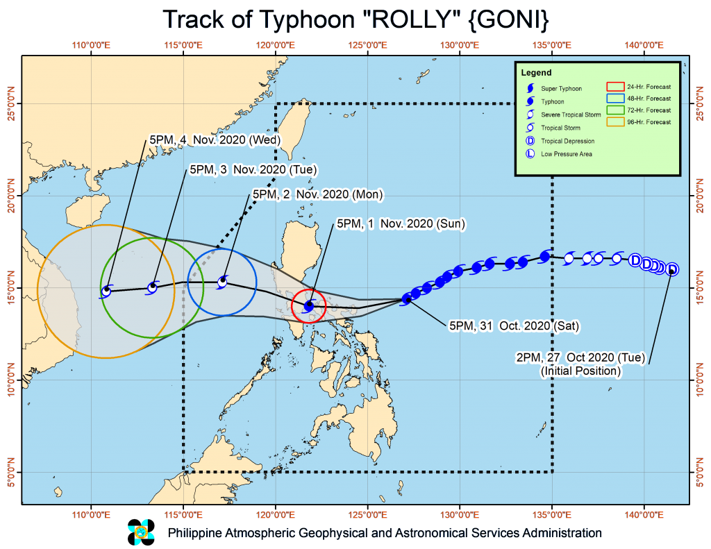
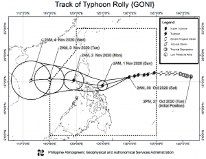
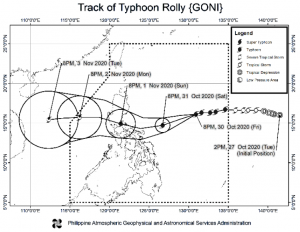
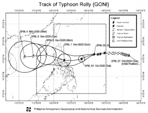
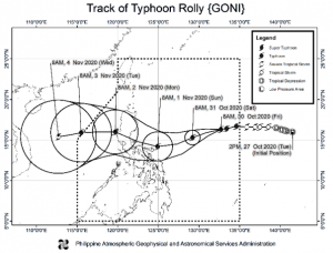
Location of Eye/center: At 7:00 PM today, the eye of Typhoon “ROLLY” was located based on all available data at 280 km East Northeast of Virac, Catanduanes (14.3 °N, 126.7 °E )
Movement: Moving West Southwestward at 20 km/h
Strength: Maximum sustained winds of 215 km/h near the center and gustiness of up to 265 km/h
Forecast Position:
- 24 Hour(Tomorrow afternoon): In the vicinity of Pagbilao, Quezon(14 °N, 121.8 °E)
- 48 Hour(Monday afternoon):310 km West of Iba, Zambales( 15.3 °N, 117.1 °E)
- 72 Hour(Tuesday afternoon): 720 km West of Iba, Zambales( 15.0 °N, 113.3 °E)
- 96 Hour(Wednesday afternoon):1,020 km West of Central Luzon( 14.8 °N, 110.8 °E)
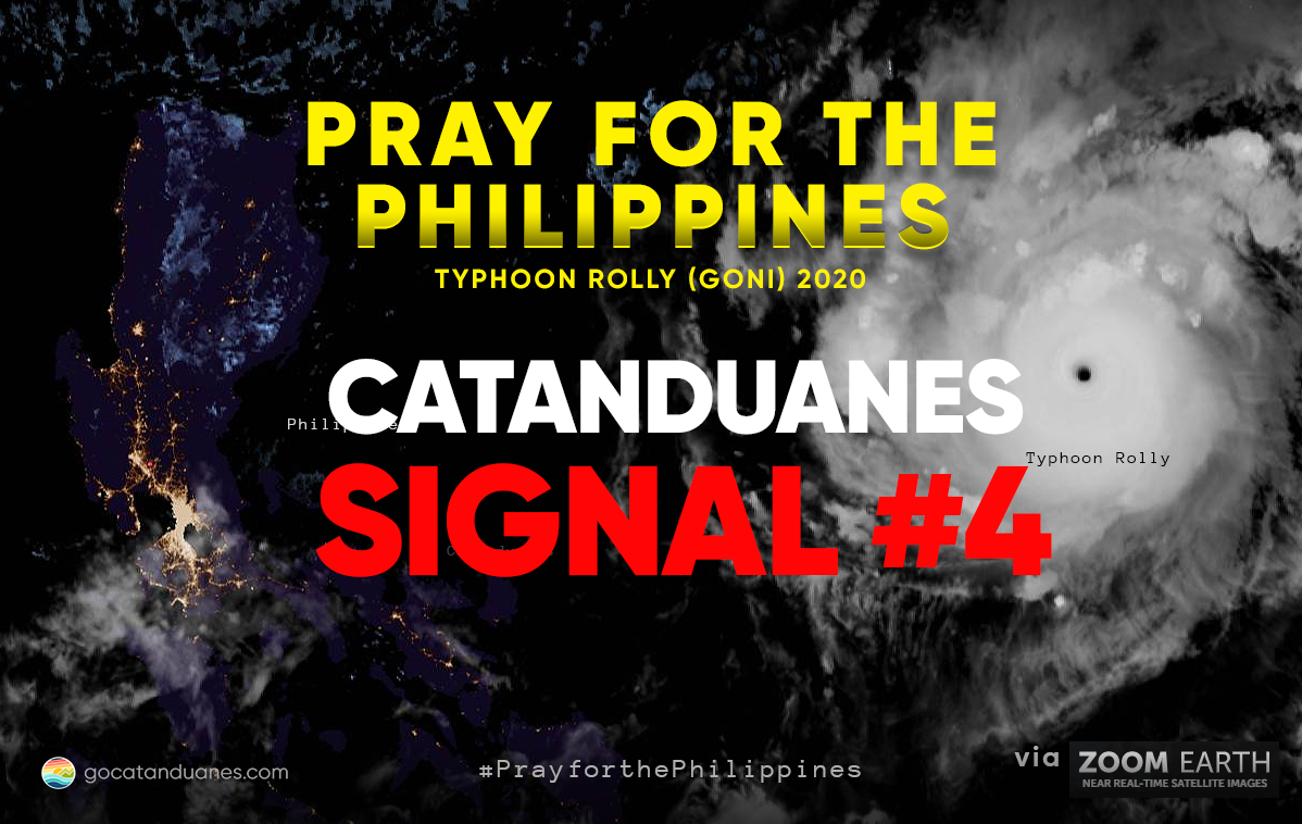
Tropical Cyclone Wind Signal no. 4
- Luzon
- Catanduanes and the eastern portion of Camarines Sur (Siruma, Tinambac, Goa, Lagonoy, San Jose, Garchitorena, Presentacion, Caramoan)
Tropical Cyclone Wind Signal no. 3
- Luzon
- Camarines Norte, the rest of Camarines Sur, Albay, Sorsogon, Burias and Ticao Islands, Marinduque, and the southern portion of Quezon (Atimonan, Pagbilao, Padre Burgos, Agdangan, Unisan, Plaridel, Gumaca, Pitogo, Macalelon, Lopez, General Luna, Catanauan, Mulanay, San Francisco, San Andres, San Narciso, Buenavista, Guinayangan, Tagkawayan, Calauag, Quezon, Alabat, Perez)
- Visayas
- Northern Samar
Tropical Cyclone Wind Signal no. 2
- Luzon
- Pampanga, Bulacan, the southern portion of Nueva Ecija (Cabiao, San Isidro, Gapan City, General Tinio, Peñaranda, San Antonio, Jaen, San Leonardo, Santa Rosa, Cabanatuan City, Palayan City, Laur, Gabaldon, Bongabon), the southern portion of Zambales (San Marcelino, San Felipe, San Narciso, San Antonio, Castillejos, Subic, Olongapo City), Bataan, Metro Manila, Rizal, Cavite, Batangas, Laguna, the southern portion of Aurora (Maria Aurora, San Luis, Baler, Dingalan), the rest of Quezon including Polillo Islands, the rest of Masbate, Romblon, Oriental Mindoro, and Occidental Mindoro including Lubang Island
- Visayas
- The northern portion of Samar (Catbalogan City, Jiabong, Motiong, Paranas, Hinabangan, San Sebastian, Tarangnan, San Jorge, San Jose de Buan, Matuguinao, Gandara, Santa Margarita, Calbayog City, Santo Nino, Almagro, Tagapul-An), the northern portion of Eastern Samar (San Julian, Sulat, Taft, Can-Avid, Dolores, Maslog, Oras, San Policarpo, Arteche, Jipapad), the extreme northern portion of Antique (Pandan, Libertad, Caluya), and the northwestern portion of Aklan (Buruanga, Malay, Nabas, Ibajay)
Tropical Cyclone Wind Signal no. 1
- Luzon
- The rest of Zambales, Tarlac, the rest of Nueva Ecija, the rest of Aurora, Pangasinan, La Union, the southern portion of Ilocos Sur (Quirino, Gregorio Del Pilar, Salcedo, San Emilio, Candon City, Galimuyod, Santa Lucia, Cervantes, Sigay, Santa Cruz, Suyo, Tagudin, Alilem, Sugpon), Mountain Province, Benguet, Ifugao, Nueva Vizcaya, Quirino, the central and southern portions of Isabela (Mallig, Quirino, Ilagan, Roxas, San Manuel, Burgos, Gamu, Palanan, San Mariano, Benito Soliven, Naguilian, Reina Mercedes, Luna, Aurora, Cabatuan, San Mateo, Cauayan City, Dinapigue, San Guillermo, Echague, San Agustin, Jones, Angadanan, Alicia, San Isidro, Ramon, Santiago City, Cordon), and Calamian Islands
- Visayas
- Biliran, the northern portion of Antique (Sebaste, Culasi), the rest of Aklan, the northern portion of Capiz (Jamindan, Mambusao, Sapi-An, Ivisan, Roxas City, Panay, Pilar, Sigma, Dao, Panitan, Pontevedra, President Roxas), and the northern portion of Iloilo (Carles, Balasan, Estancia, Batad)
SEVERE WEATHER BULLETIN #7
ISSUED AT 11:00 AM, 31 October 2020
Location of eye/center: At 10:00 AM today, the eye of Typhoon “ROLLY” was located based on all available data at 480 km East Northeast of Virac, Catanduanes(15.1°N, 128.4°E).
Strength: Maximum sustained winds of 215 km/h near the center and gustiness of up to 265 km/h.
Movement: Moving West Southwestward at 20 km/h.
Forecast Positions: • 24 Hour (Tomorrow morning): 70 km East of Daet, Camarines Norte (14.1°N, 123.6°E) • 48 Hour (Monday morning):160 km West of Iba, Zambales (15.2°N, 118.5°E) • 72 Hour (Tuesday morning): 620 km West of Iba, Zambales (OUTSIDE PAR) (15.4°N, 114.2°E) • 96 Hour (Wednesday morning):900 km West of Central Luzon (OUTSIDE PAR) (15.0°N, 111.6°E)
TROPICAL CYCLONE WIND SIGNAL
TCWS 3
- Luzon: Catanduanes
TCWS 2
- Luzon: The central and southern portions of Quezon (Mauban, Sampaloc, Lucban, Candelaria, Dolores, Tiaong, San Antonio, Sariaya, Tayabas City, Lucena City, Pagbilao, Atimonan, Padre Burgos, Agdangan, Unisan, Plaridel, Gumaca, Pitogo, Macalelon, General Luna, Catanauan, Mulanay, San Francisco, San Andres, San Narciso, Buenavista, Lopez, Calauag, Guinayangan, Tagkawayan, Quezon, Alabat, Perez) including Polillo Islands, Camarines Norte, Camarines Sur, Albay, Sorsogon, Burias and Ticao Islands, and Marinduque
- Visayas: Northern Samar
TCWS 1
- Luzon: The rest of Masbate, the rest of Quezon, Rizal, Laguna, Cavite, Batangas, Romblon, Occidental Mindoro including Lubang Island, Oriental Mindoro, Metro Manila, Bulacan, Pampanga, Bataan, Zambales, Tarlac, Nueva Ecija, Aurora, Pangasinan, La Union, Benguet, Ifugao, Nueva Vizcaya, Quirino, and the southern portion of Isabela (Aurora, Luna, Reina Mercedes, Naguilian, Benito Soliven, San Mariano, Palanan, Dinapigue, San Guillermo, Echague, San Agustin, Jones, Cordon, Santiago City, Ramon, San Isidro, Angadanan, Alicia, Cauayan City, Cabatuan, San Mateo)
- Visayas: The northern portion of Samar (Tagapul-An, Almagro, Santo Nino, Tarangnan, Catbalogan City, Calbayog City, Santa Margarita, Gandara, Pagsanghan, San Jorge, Jiabong, Motiong, Paranas, San Jose de Buan, Matuguinao), the northern portion of Eastern Samar (Taft, Can-Avid, Dolores, Maslog, Jipapad, Arteche, Oras, San Policarpo), and Biliran
SEVERE WEATHER BULLETIN #6
ISSUED AT 8:00 AM, 31 October 2020
Location of eye/center: At 7:00 AM today, the eye of Typhoon “ROLLY” was located based on all available data at 540 km East Northeast of Virac, Catanduanes (15.4°N, 128.9°E).
Strength: Maximum sustained winds of 215 km/h near the center and gustiness of up to 265 km/h.
Movement: Moving Westward at 20 km/h.
Forecast Positions:
• 24 Hour (Tomorrow morning): 80 km North of Virac, Catanduanes (14.3°N, 124.1°E)
• 48 Hour (Monday morning): 105 km West of Iba, Zambales (15.4°N, 119.0°E)
• 72 Hour (Tuesday morning): 600 km West of Iba, Zambales (OUTSIDE PAR) (15.5°N, 114.4°E)
• 96 Hour (Wednesday morning): 955 km West of Central Luzon (OUTSIDE PAR) (15.3°N, 111.1°E)
TROPICAL CYCLONE WIND SIGNAL
TCWS 2
- Luzon: Catanduanes, Camarines Norte, Camarines Sur, Albay, Sorsogon, Burias Island, and the southeastern portion of Quezon (San Francisco, San Andres, San Narciso, Mulanay, Catanauan, Buenavista, Lopez, Guinayangan, Calauag, Tagkawayan)
TCWS 1
- Luzon: The rest of Masbate including Ticao Island, the rest of Quezon including Polillo Islands, Rizal, Laguna, Cavite, Batangas, Marinduque, Romblon, Occidental Mindoro including Lubang Island, Oriental Mindoro, Metro Manila, Bulacan, Pampanga, Bataan, Zambales, Tarlac, Nueva Ecija, Aurora, Pangasinan, La Union, Benguet, Ifugao, Nueva Vizcaya, Quirino, and the southern portion of Isabela (Aurora, Luna, Reina Mercedes, Naguilian, Benito Soliven, San Mariano, Palanan, Dinapigue, San Guillermo, Echague, San Agustin, Jones, Cordon, Santiago City, Ramon, San Isidro, Angadanan, Alicia, Cauayan City, Cabatuan, San Mateo).
- Visayas: Northern Samar, the northern portion of Samar (Tagapul-An, Almagro, Santo Nino, Tarangnan, Catbalogan City, Calbayog City, Santa Margarita, Gandara, Pagsanghan, San Jorge, Jiabong, Motiong, Paranas, San Jose de Buan, Matuguinao), the northern portion of Eastern Samar (Taft, Can-Avid, Dolores, Maslog, Jipapad, Arteche, Oras, San Policarpo), and the northern portion of Biliran (Kawayan, Maripipi)
SEVERE WEATHER BULLETIN #5
ISSUED AT 5:00 AM, 31 October 2020
Location of eye/center: At 4:00 AM today, the eye of Typhoon “ROLLY” was located based on all available data at 605 km East Northeast of Virac, Catanduanes (15.7°N, 129.4°E).
Strength: Maximum sustained winds of 215 km/h near the center and gustiness of up to 265 km/h.
Movement: Moving Westward at 20 km/h.
Forecast Positions:
• 24 Hour (Tomorrow morning): 110 km Northeast of Virac, Catanduanes (14.3°N, 124.9°E)
• 48 Hour (Monday morning):50 km West of Iba, Zambales (15.3°N, 119.5°E)
• 72 Hour (Tuesday morning): 545 km West of Iba, Zambales (OUTSIDE PAR) (15.5°N, 114.9°E)
• 96 Hour (Wednesday morning):910 km West of Central Luzon (OUTSIDE PAR) (15.3°N, 111.5°E)
TROPICAL CYCLONE WIND SIGNAL
TCWS 2
- Luzon: Catanduanes, the eastern portion of Camarines Sur (Caramoan, Garchitorena, Lagonoy, Tinambac, Siruma, Presentacion, San Jose, Goa, Buhi, Sagnay, Tigaon, Ocampo, Iriga City, Baao, Nabua, Bato, Balatan, Bula, Pili, Calabanga, Naga City, Bombon,
Magarao, Canaman, Gainza, Milaor, Camaligan, Minalabac), Albay, and Sorsogon
TCWS 1
- Luzon: Camarines Norte, the rest of Camarines Sur, Masbate including Ticao and Burias Islands, Quezon including Polillo Islands, Rizal, Laguna, Cavite, Batangas, Marinduque, Romblon, Occidental Mindoro including Lubang Island, Oriental Mindoro, Metro Manila, Bulacan, Pampanga, Bataan, Zambales, Tarlac, Nueva Ecija, Aurora, Pangasinan, Benguet, Ifugao, Nueva Vizcaya, Quirino, and the southern
portion of Isabela (Aurora, Luna, Reina Mercedes, Naguilian, Benito Soliven, San Mariano, Palanan, Dinapigue, San Guillermo, Echague, San Agustin, Jones, Cordon, Santiago City, Ramon, San Isidro, Angadanan, Alicia, Cauayan City, Cabatuan, San Mateo). - Visayas: Sur, Masbate including Ticao and Burias Islands, Quezon including Polillo Islands, Rizal, Laguna, Cavite, Batangas, Marinduque, Romblon, Occidental Mindoro including Lubang Island, Oriental Mindoro, Metro Manila, Bulacan, Pampanga, Bataan, Zambales, Tarlac, Nueva Ecija, Aurora, Pangasinan, Benguet, Ifugao, Nueva Vizcaya, Quirino, and the southern portion of Isabela (Aurora, Luna, Reina Mercedes, Naguilian, Benito Soliven, San Mariano, Palanan, Dinapigue, San Guillermo, Echague, San Agustin, Jones, Cordon, Santiago City, Ramon, San Isidro, Angadanan, Alicia, Cauayan City, Cabatuan, San Mateo). Northern Samar, the northern portion of
Samar (Tagapul-An, Almagro, Santo Nino, Tarangnan, CatbaloganCity, Calbayog City, Santa Margarita, Gandara, Pagsanghan, San Jorge, Jiabong, Motiong, Paranas, San Jose de Buan, Matuguinao), the northern portion of Eastern Samar (Taft, Can-Avid, Dolores, Maslog, Jipapad, Arteche, Oras, San Policarpo), and the northern portion of Biliran (Kawayan, Maripipi)
SEVERE WEATHER BULLETIN #4
ISSUED AT 11:00 PM, 30 October 2020
Location of eye/center: At 10:00 PM today, the eye of Typhoon “ROLLY” was located based on all available data at 895 km East of Casiguran, Aurora (16.0°N, 130.5°E).
Strength: Maximum sustained winds of 215 km/h near the center and gustiness of up to 265 km/h.
Movement: Moving West Southwestward at 15 km/h.
Forecast Positions:
• 24 Hour (Tomorrow evening): 295 km East Northeast of Virac, Catanduanes (14.7°N, 126.7°E)
• 48 Hour (Sunday evening): In the vicinity of General Nakar, Quezon (14.9°N, 121.4°E)
• 72 Hour (Monday evening): 445 km West of Dagupan City, Pangasinan (15.7°N, 116.2°E)
• 96 Hour (Tuesday evening): 825 km West of Central Luzon (OUTSIDE PAR) (15.4°N, 112.3°E)
TROPICAL CYCLONE WIND SIGNAL
TCWS 1
- LUZON: Catanduanes, Camarines Norte, Camarines Sur, Albay, Sorsogon, Masbate including Ticao and Burias
Islands, Quezon including Polillo Islands, Rizal, Laguna, Marinduque, and Romblon - VISAYAS: Northern Samar, the northern portion of Samar (Tagapul-An, Almagro, Santo Nino, Tarangnan, Catbalogan City, Calbayog City, Santa Margarita, Gandara, Pagsanghan, San Jorge, Jiabong, Motiong, Paranas, San Jose de Buan, Matuguinao), the northern portion of Eastern Samar (Taft, CanAvid, Dolores, Maslog, Jipapad, Arteche, Oras, San Policarpo), and the northern portion of Biliran (Kawayan, Maripipi)
SEVERE WEATHER BULLETIN #3
ISSUED AT 5:00 PM, 30 October 2020
Location of eye/center: At 4:00 PM today, the eye of Typhoon “ROLLY” was located based on all available data at 980 km East of Casiguran, Aurora (16.2°N, 131.3°E).
Strength: Maximum sustained winds of 185 km/h near the center and gustiness of up to 230 km/h.
Movement: Moving Westward at 20 km/h.
Forecast Positions:
• 24 Hour (Tomorrow afternoon): 685 km East of Infanta, Quezon (15.0°N, 128.0°E)
• 48 Hour (Sunday afternoon):55 km North of Daet, Camarines Norte (14.6°N, 123.0°E)
• 72 Hour (Monday afternoon): 260 km West of Dagupan City, Pangasinan (16.1°N, 117.9°E)
• 96 Hour (Tuesday afternoon):670 km West of Dagupan City, Pangasinan (OUTSIDE PAR) (15.8°N, 114.1°E)
• 120 Hour (Wednesday afternoon):900 km West of Central Luzon (OUTSIDE PAR) (15.6°N, 111.6°E)
TROPICAL CYCLONE WIND SIGNAL
TCWS 1
- Catanduanes
SEVERE WEATHER BULLETIN #2
ISSUED AT 11:00 AM, 30 October 2020
Location of eye/center: At 10:00 AM today, the eye of Typhoon “ROLLY” was located based on all available data at 1,100
km East of Central Luzon(16.3°N, 132.4°E).
Strength: Maximum sustained winds of 165 km/h near the
center and gustiness of up to 205 km/h.
Movement: Moving Westward at 15 km/h.
Forecast Positions:
• 24 Hour (Tomorrow morning): 815 km East of Infanta, Quezon (15.3°N, 129.2°E)
• 48 Hour (Sunday morning):210 km East of Daet, Camarines Norte (14.2°N, 124.9°E)
• 72 Hour (Monday morning): 70 km West of Dagupan City, Pangasinan (16.0°N, 119.7°E)
• 96 Hour (Tuesday morning):515 km West of Dagupan City, Pangasinan (OUTSIDE PAR) (15.9°N, 115.5°E)
• 120 Hour (Wednesday morning):780 km West of Iba, Zambales (OUTSIDE PAR) (15.4°N, 112.7°E)
NO TROPICAL CYCLONE WIND SIGNAL
SEVERE WEATHER BULLETIN #1
ISSUED AT 11:00 PM, 29 October 2020
Location of eye/center: At 10:00 PM today, the eye of Typhoon “ROLLY” was located based on all available data at 1,280 km East of Central Luzon (16.5°N, 134.1°E).
Strength: Maximum sustained winds of 120 km/h near the center and gustiness of up to 150 km/h.
Movement: Moving Westward at 20 km/h.
Forecast Positions:
• 24 Hour (Tomorrow evening): 970 km East of Central Luzon (16.3°N, 131.2°E)
• 48 Hour (Saturday evening):740 km East of Infanta, Quezon (15.2°N, 128.5°E)
• 72 Hour (Sunday evening): 255 km East of Infanta, Quezon (14.9°N, 124.0°E)
• 96 Hour (Monday evening):40 km North Northwest of Dagupan City, Pangasinan (16.4°N, 120.2°E)
• 120 Hour (Tuesday evening):325 km West of Dagupan City, Pangasinan (16.4°N, 117.3°E)
NO TROPICAL CYCLONE SIGNAL

Source: http://bagong.pagasa.dost.gov.ph/